
Southern Road Trip - November 24 - December 3
For years I'd heard of people going south, to rock climb etc in Red Rocks or some such. But the thought of taking vacation in winter for such a thing never really appealed to me, for whatever reason. There is just too much to do in the summer, to "waste" vacation time in the winter I thought. Then one day it just finally made sense. Maybe I just was having a particularly hard transition out of summer this year. I was sold for sure when I found Charleston Peak, a mountain over 11,000 feet that you can climb late into the season and has a trail right to the top. So I started planning, researching, and setting up itineraries. Research is so much fun! Eventually I settled on a trip itinerary I thought I could follow. Then at the last minute, I changed it again to make the first day more ambitious. Which of course messed up what was to follow. It was worth it though.
After months of planning on and off, I finally packed up the car and started out on the night of the 23rd. The car contained a box of food, a plastic bin of clothing, my packs, camping stuff, and a large water container. I didn't make it across the border that night. The next morning I woke up, and went off to the United States.
I had a few goals for this trip. One of which was to spend zero dollars on accommodation. I didn't quite manage that, but I came really close. Only spending $15 on the one night in Red Rocks Campground. I regret that; but I am glad it saved me time and gas money to get to and from the free sites farther out of town, on the night before Gunsight Notch Peak.
Similarly I hoped to spend very little on food. I only ate out at restaurants four times, all for dinner. Breakfast, and lunch were always oatmeal and bars or snacks. I could have done quite a bit better on eating cheaply, but I was on holiday and not trying to live forever on a dime. So it didn't really matter as long as I could afford it.
Another was to climb as many peaks as possible, which I did minus the day I spent in Valley of Fire State Park. That day my lower back hurt quite badly from parking my SUV at too much of an angle. So I felt like I couldn't really scramble even the smallest of Red Rock peaks safely. I was probably wrong, as it warmed up with hiking, but once I'd thought up the side trip to somewhere new I had no motivation for anything else. So there was little point starting out. My failure rate is high when I start with such poor motivation.
The last (being somewhat contrary to the previous goal), was to have a great time! So I'd included a day going to see the world famous Zion, and hike its two most popular trails that aren't canyons. As well as stopping at hot springs on the way down and up. Heading for the super popular Goldbug in Idaho on my last hiking day.
Day 1 - November 24 (Friday)
I made good progress down the I-15 only stopping for gas in Great Falls, Butte and Pocatello. Then two rest area stops in between to brew up some more coffee and eat some smoked salmon and cream cheese on crackers. My coworker had purchased a large smoked salmon for me at Costco before the trip. In Butte I also went to a grocery store in to get some vegetables, since you cannot cross the border with those. Which is silly. In the store the woman behind me mentioned something about my veggies and I had to correct her that no, I wasn't the worlds most healthiest eater. All the cookies and other junk were already in the car. I had brought a bottle of wine from home that I hadn't had time to drink before I left so I didn't need to buy liquor just yet.
Finally I made it to the general area I would camp at. I took a side trip down the number 30, to the town of Lava Hot Springs. As a unrepentant peakbagger I tried to drive up the road to access "Mount Moh", which is a hill just south of town. But the road was too muddy and rutty. In Canada I might have tried it, but there was no way I was getting stuck on the first day of my road trip in the USA. I also didn't feel like walking from where I could park. As it would turn a 15 minute round trip peak, into an hour or so expedition, and it was just about sunset. So I went back into town to find the hot springs.

I mistakenly went to Lava Hot Springs Inn's pools instead of the large commercial pool at Lava Hot Springs. I only discovered this while writing up this blog, as I searched for websites to link. The Inn has two normal pools of varying temperatures. Then a pool that is sort of part of the garden (pictured here), and two hotter round tubs farther back. It's all the same water coming out of the ground (you would hope). As well the Inn had a neat garden and old building to look at. Which made it more interesting and quaint. Especially when I was told that it used to be a Sanitarium / Hospital which is actually haunted. I stayed there for a few hours soaking. Before finally leaving, as I knew I still had to make it to camp and eat dinner.

I had decided to camp at the free campsite on BLM land at Hawkins Reservoir which is just ~13km west of the I-15, from the town of Virgina. It had parking and toilets. Which is really all you need when sleeping in your car. You can do with less actually, since outhouses are a luxury (depending on your opinion of them, their condition, and the temperature outside). It was also far enough off the road to be quite. It turned out to be empty at this time of year. I cooked up some mac and cheese on the long suffering jet boil, and my nice aluminum backpacking pot. Something which takes far longer that way than if I'd ever bothered to buy and learn how to use a real stove; but oh well. I had wine to drink while I waited, and (as I like to call them) "dramatization" photos to take. As pictured here. Pretending that I don't just sit on the cooler and shovel food into my mouth like a cave-woman. I finished my dinner, read a bit and went to bed. Probably around 8pm.
Day 2 - November 25 (Saturday)
I woke up at 4am freezing cold. Looking back on it, it was probably half a problem to do with humidity rather than the set up, because I'd had the wet towel and swimming suit in the car with me. At the time all I could think about was that the sleeping mat was sucking in cold air from inside and outside of the car, and then delivering it into me wherever pressure was the greatest. I decided to go get an insulted sleeping pad at REI to fix this, and felt silly for not just talking the one I already owned. It was only -4 outside, so it wasn't even that cold. I gave up on sleep, scraped the ice off the windows, and drove off. After not too long I got to the never ending region of Salt Lake City, then finally out into open country again around 10am. Where I found a rest stop to get gas. Then took a quick 1.5 hour nap in the car. Toasty warm now that the sun was up.
Some random things I thought on the drive down:
- How are gallons still a unit of measurement? (having completely forgotten the conversion rate to litres)
- Why are sloths an attraction at the aquarium; not being an aquatic creature?
- Why did you come all the way from California just to murder that tree for x-mas?

I had a nice lunch on the side of the road in the short section where the I-15 goes through Arizona in the Virgin River Gorge. Along the Rd 1005.
I also finished my radio drama of Neil Gaiman's "Neverwhere", before I even finished the drive down. I enjoy listening to books rather than music (and radio plays, where all the characters are acted out by different people are even better) on super long drives. This is because it makes you only think about the story, and not any other random things which might be bothering/worrying you. Plus it keeps you alert much better. It is really too bad are not more radio plays out there.
In Las Vegas I bought the insulated sleeping pad I required at REI, and a six pack of beer at a huge liquor store beside it. Then I tried to get gas. Which isn't possible in Las Vegas for Canadians via credit card, because they require a ZIP code. This annoyed me endlessly, and eventually I paid cash. Already mad at the city I zoomed out to the Mount Charleston area of the Spring Mountains. I checked out parking for the mountain tomorrow, then headed off for Champion Road where you are allowed to "dispersed camp" for free. There were lots of nice sites along the dirt road of a wilderness nature (no washrooms), and I didn't see anyone else. Mine had a nice view of the northern outliers of Mummy Mountain.

I set my alarm for quite early and went to bed before 8pm. Obviously with the trunk closed, and the cooler in the car, but also sleeping the opposite direction (this being another one of those "dramatization" photos). Hoping for a better sleep than the night before. I didn't mind going to bed so early as to get 10 hours of sleep. I figured I needed it for the day ahead.
Day 3 - November 26 (Sunday)
However I hadn't noticed I'd crossed a time zone, and therefore that my phone was producing results in the new one. I'd set it to wake me up an hour before sunrise. But actually due to the time zone change, it woke me up at sunrise. Seeing this I cooked up breakfast, and finished packing in a hurry. Packing both my backpack for the day, and the items in my SUV in an attempt to hide the most expensive items (sleeping bag, sleeping pad), under cheaper items (cotton hoodie, wool blanket).

Sunrise was beautiful as I drove along the road back to the southern loop parking lot, but I was supposed to already be hiking by this point! There was too limited daylight as it was, and I had an overly ambitious plan to turn a typical two mountain day into a three mountain one. By adding Mummy Mountain to Griffith and Charleston. The problem being that there was only 10 hours of daylight, and this plan would take 11 to 12 hours. I didn't want to spend too much time in the dark, or be overly rushed. Which was why I'd wanted to start walking at dawn. Oh well...

I started at 7:44am up the Southern Loop trail. Hiking up the trail at a fast pace towards the ridgeline. Though I did take time to take this one selfie photo of me hiking away from the camera. But otherwise I stuck to the business at hand. Eating and walking at the same time, as I'd trained myself to do for ski touring season. I made swift progress despite the fact that I had packed my large pack full of extra jackets etc. Not knowing how cold it would feel on the ridge in the wind. As well as for emergencies.

There was a wonderful viewpoint part ways up that showed Charleston Peak way off in the distance.

As well as mummy Mountain across the valley.

I made it to the ridgeline a bit sooner than I'd expected, which was a nice surprise. Then continued onto the summit of Griffith Peak. A short 45 minute (return) detour to the south. This photo is looking southwest.

Summit of Griffith Peak (3371m) looking north. You will notice the rapid degeneration of summit photos of me, as time passes on this trip....

Afterwards I continued on the ridge trail through the meadow, then the burned forest area, and finally above treeline, heading up the final stretch to Charleston Peak.

Summit of Charleston Peak (3632m). The highest peak in southern Nevada. Here I just let a nice old man take my photo, rather than worrying about the best angle. He confirmed to me that my three summit plan was not insane, and that even if it didn't pan out taking the northern loop down was worth the extra 2km road walk at the end of the day between parking lots. So I committed myself to that plan. When up to that point I'd still been debating it, deciding that I would make my final decision to go for it or not on the summit of Charleston, after I'd seen how long that portion of the trip took me.

Summit of Charleston Peak looking northeast at Mummy Mountain.

View after starting down, looking into the valley I'm circling in a U on this trip. Which is to the east.
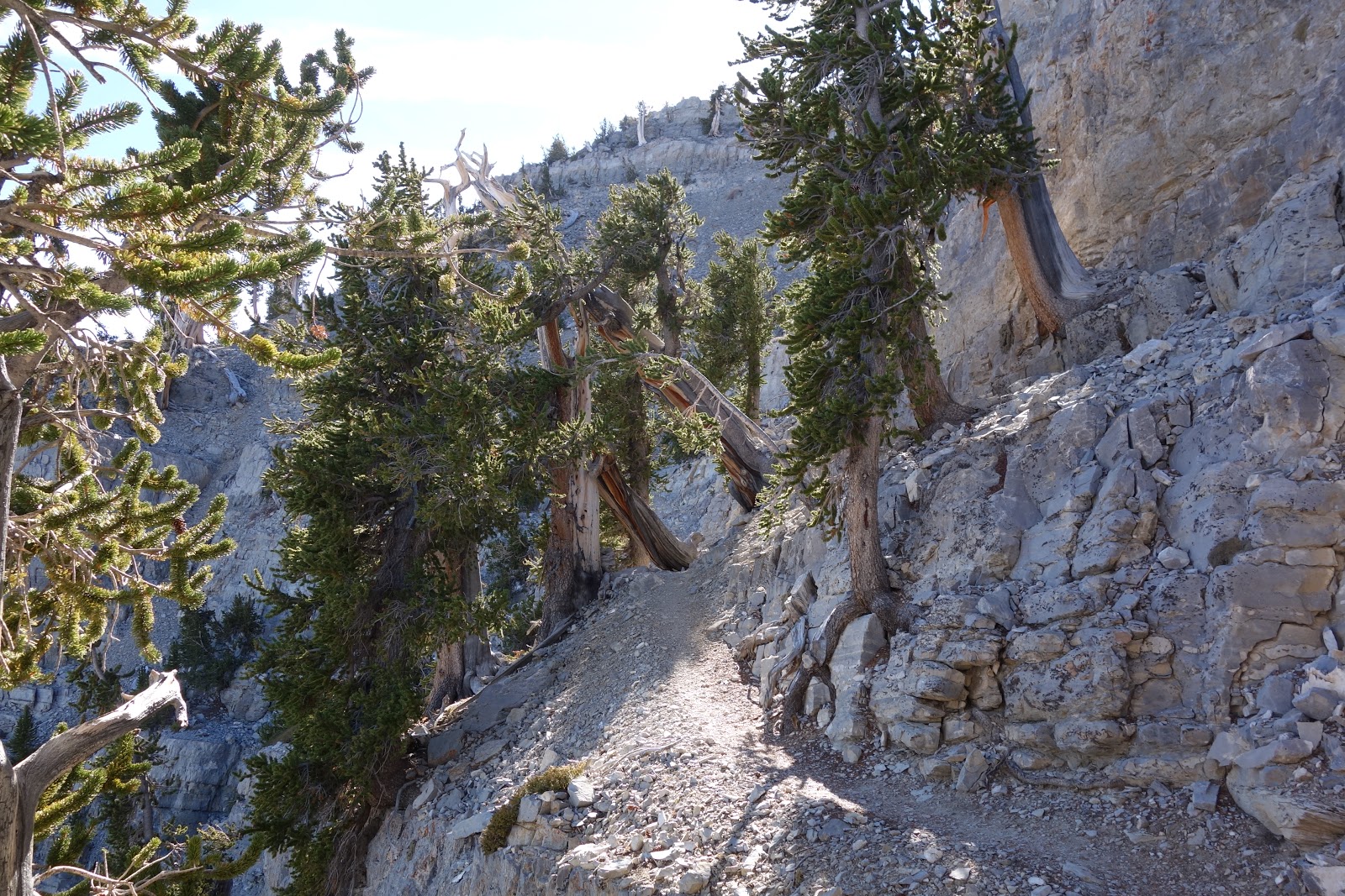
Very neat trail between rock bands, and interesting trees. This went on for quite a while. The northern loop trail does traverse quite a bit though, and eventually started to get a bit tedious. For all that it was a nice wide official trial. The views along it were great, and it was a well built trail. However I didn't have much time to appreciate it, as I had to get over to the turn off for Mummy Mountain before my designated cut off time. I wanted to be up and down the peak before sunset.

View down from the top of the scree run going up Mummy Mountain. When starting out at the turn off (which I found easy to find), very little of me had wanted to do this extension at all. However I knew I'd regret it if I did not. I'd started up at 3:05pm, which was just past my cut off time. Meaning that there was only an hour and a half till sunset. Then about half an hour of twilight until full on dark. I did wonder as I started up: Isn't this type of terrain that I'd come to Las Vegas to avoid? Scree? Shouldn't I be scrambling in Red Rocks on beautiful sandstone right now? Oh no; wait, I guess it was just the snow I was avoiding. Well that was successful at least...

Looking up at the start of the ridge, from just above the scree. The weakness to get through the cliffs is really obvious. I followed a faint trail along the ridge, and then traversed under the summit cliffs to the weakness. I then easily scrambled up the gully, and completed the short hike to the summit. A rather unimpressive summit, but I was happy nontheless.

Summit of Mummy Mountain (3514m) looking north. Isn't this a great photo? Not. If I look happy, I'm only happy I'm done making myself walk uphill. Now for downhill.

Photo from the start of the descent down the gully, which is the weakness in the summit cliffs. After taking photos, I hurried down. I got down to the trail again at about 4:30pm. So a full hour before sunset. I put on my headlamp during a quick food break, and started down the trail as fast as I safely could. As the sun set and the light faded, I'd thankfully had already passed the turn off of the Northern Loop trail, and the Trail Canyon trail (yes it is really called that...). Then it was just the long hike down that to the parking area and the 2km along the road. Total trip: ~32km / 1845m / 11h. I was going fast. Darkness being a great motivation for speed.
As I got to my car there was a parks truck there waiting for hikers. The parks guy said he was shutting down the parking lot for the season! He wondered if I knew where the people who owned the other two cars where. I didn't, and I warned him I was going to change in the parking lot before eating so I could go to Mount Charleston Lodge for dinner. He warned me the bathrooms were already locked. I told him he'd misunderstood me, I was going to change next to my car.... I'd only told him so he would avoid looking that way, and not get mad it was taking me so long to leave the parking lot (my social awkwardness thinking that this would be a problem, when clearly he had to wait for the other two cars worth of people to show up anyway).... He seemed embarrassed, and said that they didn't mind people being too dirty, and off I went.
I had a nice meal out at the lodge, which was my first meal out of the trip. I sat by a large fireplace, and had a beer and burger. Then I drove back to my lovely camping area from the night before, and went to bed. Blistered, tired and sore, but very satisfied with my trip. I think the only reason I got blisters (which almost never happens to me), wasn't the length of the day, but that my feet overheated in my winter hiking boots. They weren't needed, and the extra heat caused too much friction. In bed I read for a bit drinking another beer, then went to sleep.
Day 4 - November 27 (Monday)
I woke up later than sunrise to a bit of a weather system. It was clear that it was raining/snowing up on Mount Charleston, and it was pretty windy down where I was. I was super happy about completing Charleston on what perhaps was the last day it would be snow free (it wasn't, it turned out to be a very dry winter for the southern states). I had breakfast and started off down to Red Rocks Canyon.
Driving down the 156 back to the 95 which would take me to Las Vegas, I noticed something I hadn't on the way in. There had been (and where on the way down as well) plenty of signs on the road stating where say 6000ft and 7000ft are. But I hadn't thought much about it. However driving down the 156, it felt like the land was falling away. The car sort of fell/rolled downhill for miles upon miles. Where I'd parked on Champion road was about 7800ft. The junction of the 156 and 95 is 3300ft. And the whole descent is almost at the same angle. It was the weirdest thing. Therefore why an 11,000er is just sitting just outside Las Vegas; when the general area surrounding it, is not very high in elevation.
After skirting around Vegas as best I could, I drove to Red Rocks Canyon and paid the entry fee. I then filled up my water jug at the water bottles filler (not really what they made it for I know, but some of that water would eventually go into bottles). Then tried to decide what to do. It was sunny here but still very windy. I'd thought about hiking up Turtlehead Mountain but didn't feel like it in the wind. Which was gusting up to 60 miles/hour. So I headed over to the first stop on the scenic drive: Calico Hills.

A lot of people had parked and were taking selfies from the pullout with the hills in the background. However for once, almost as many were rock climbers gearing up, and heading off to some crag or other. Which was super neat. I headed off to some nearby rocks to play around. Since I didn't have an objective and timeline, this of course had to involve getting some shots for the gram. The landscape was very beautiful and fun to scramble around on. I could probably have easily made it up the hill, as it was in the book. But I didn't think of that until much later. Until I'd already left and drove over to Calico Basin and started up the peak I had planned on doing on my rest day: Foundation Peak. By then it was too late more or less. Since I hadn't read the description of Calico Hills beforehand, it wasn't immediately obvious that I'd made a mistake. I also didn't realize that Calico Hills are actually higher than Foundation Peak, and therefore a better objective.

The rock was seriously beautiful and my new Scarpa approach shoes worked perfectly on it. Keeping me stuck on angles I would normally slip off in regular hiking boots. This photo not being an example of that though.

There were also mini canyons. This one actually lead nowhere.

It was all just so much fun. When I was done messing around, I finished driving the rest of the scenic loop and headed over to Calico Basin.

I found the easiest ascent from Bob Spriko's list: Foundation Peak. Only a 2km / 187m trip. Which took me only 1.25h. This little red hill sounded like a good objective for a tired, sore, blistered girl on a super windy day.

The rock; unlike on Calico Hills, was completely red and very bright in the sun. There was a way to get up the peak that basically involved no scrambling by picking the easiest path. Or you could try to make it more difficult.

The terrain was mostly like this, sometimes steeper with cliffs that you could not scramble. But a route that would work was only a short walk away.

I made it to the top only to find it was a small outlier of the Calico Hills! Which I really should have just done instead. It was still fun though, and if someone else is counting it as a peak.... then I can too!

So I descended. Getting completely off my original route up and having to move back and forth to avoid cliffs. While this wasn't a problem, it felt like a failure in my route finding ability. Also the effort involved made me question the long day I had planned tomorrow: Mount Wilson. One of the two hardest peaks in Red Rocks Canyon (the other being Bridge Mountain). I decided since I hadn't been able to complete my test piece on this day; due to my three peak day the day before, I should just complete it tomorrow instead. This test piece mountain I'd chosen was Gunsight Notch Peak. It would involve travel in a canyon, and scrambling up a small peak. Similar to Mount Wilson, but it wouldn't be nearly as hard routefinding, or as long as a day. This made me a bit sad, but it was the right decision.
After Foundation Peak I decided to go into Las Vegas with my remaining daylight. First to try to get into one of the pools I'd written down as allowing people to pay to visit, who weren't hotel guests. Caesar's Palace was open but not protected from the wind. It also didn't have a hot tub. It didn't look super appealing, so I left and went to the Pallazzo. Which had shut down its pools due to the high wind. They wanted $50 to purchase a day spa pass to use the jacuzzi tubs inside. No way I was paying that, so I left back to its lobby. Searching around on my phone for another option and finding none. And no one offered me a free drink! Two different co-workers of mine had told me previously that if a woman stands around on a casino floor, she will get free drinks from staff, to attempt to get her gambling. But nothing! When I got back they revised it to sitting at a machine but not putting in money. I still don't believe them though.
Pissed off at Las Vegas I drove off looking for a liquor store. Completely forgetting liquor is sold in every gas station and grocery store, so they do not exist in vast quantities. I eventually ended up back at the one near the REI. Where I bought quite a bit of beer, vowing never to go into the city again! I'd also stocked up on food on the way to the pool. I drove out to the country, giving in to expediency and payed my $15 to camp at the Red Rocks Parkway. It would have been a half hour drive over to Lovell Canyon, and though gas is cheap and time plentiful I was in a bad mood and didn't want to bother. I figured this way, I would for sure make it for sunrise on the scenic drive, and that would be worth it. I vowed to check out Lovell Canyon the next night instead for sure.
No comments:
Post a Comment