Athabasca Pass - Jasper National Park, AB September 8 - 13, 2015
I am starting to run out of backpacks to do in the Rockies. Not really running out (and there are always repeats), but I have done all the really popular ones except Northover Ridge / 3 Isle Lake / Turbine Canyon in Kananaskis Country. As I mentioned in my Tonquin Valley Trip Report I have done:
Assinaboine - August 13 - 17, 2011
Mt. Robson / Berg Lake - July 23 - 25, 2011
Skyline - August 14 - 16, 2010
Rockwall - August 21 - 23 2010
Skoki - Sept 5 - 7, 2009 & August 22 - 24, 2015
Tonquin - August 23 - 27, 2014
Egypt Lakes - Aug 8 - 10, 2009
Fish and Devon Lakes - July 26 - 30, 2012
Nigel Pass / Jonas Pass - July 27 – 31, 2013
Twin Lakes / Gibbon Pass / Shadow Lake - September 21 – 22, 2013
I've also did the Sawback Range Circuit last year. Which is certainly not popular, it was the start of our less than popular backpacks.
This year I decided to do Athabasca Pass. Not a popular area to go to for good reason. The trail is mostly in the trees. Except for Scott Gravel Flats you are usually in the forest, only going along next to the river for short sections. It is a true wilderness trail that lacks a lot of facilities that the more popular backcountry trails have. Bridges for one (more on that later). Also the campgrounds are just a small area without underbrush, a firebox and two tree poles. One between two trees high up, to hang your food from. One between two trees above a pit down low, to hang your @$$ from. This is the washroom. There is a general lack of people hiking this trail. That can deter people who are afraid of wildlife, or general backcountry accidents etc. I personally would not have done this alone, but with the two of us the solitude was fine.
Before I left I'd been emailing about volunteering for Parks, because I'd heard Banff needed people to take photos of signage. I wasn't going anywhere they needed in Banff though. I asked if Jasper needed the same thing. Jasper told me that they didn't - but they needed something else: people to pick up bear scat. I was skeptical at first, but decided to do it. So they mailed me a kit to collect any scat I found. What you get in return, except knowing you helped Parks knowledge of bear movements etc., is a full report on the bear whose scat you picked up. It was with the volunteer coordinators help I got updated trail information from other Parks staff that the Middle Whirlpool River had moved, and therefore the bridge no longer spans the river. As well that there was a detour to a new river crossing to avoid the Kane Creek crossing. These two river crossings worried me some on the trip in, but they both turned out to be quite manageable despite the amount of rain we'd been having recently.
So off we went. The weather forecast was not very promising. It was supposed to be raining/cloudy the first two days and the last day. This was pretty much correct. The first day it drizzled on and off for most of the morning.
(Day 1 - September 8 - In to Middleforks Campground)
We started off down the Whirlpool Fire Road. Which is a boring up and down track that goes on for 8.6km. After that you get onto the actual trail and are soon staring at your first creek crossing.
On the way in I went over the log. On the way out I didn't bother.
A
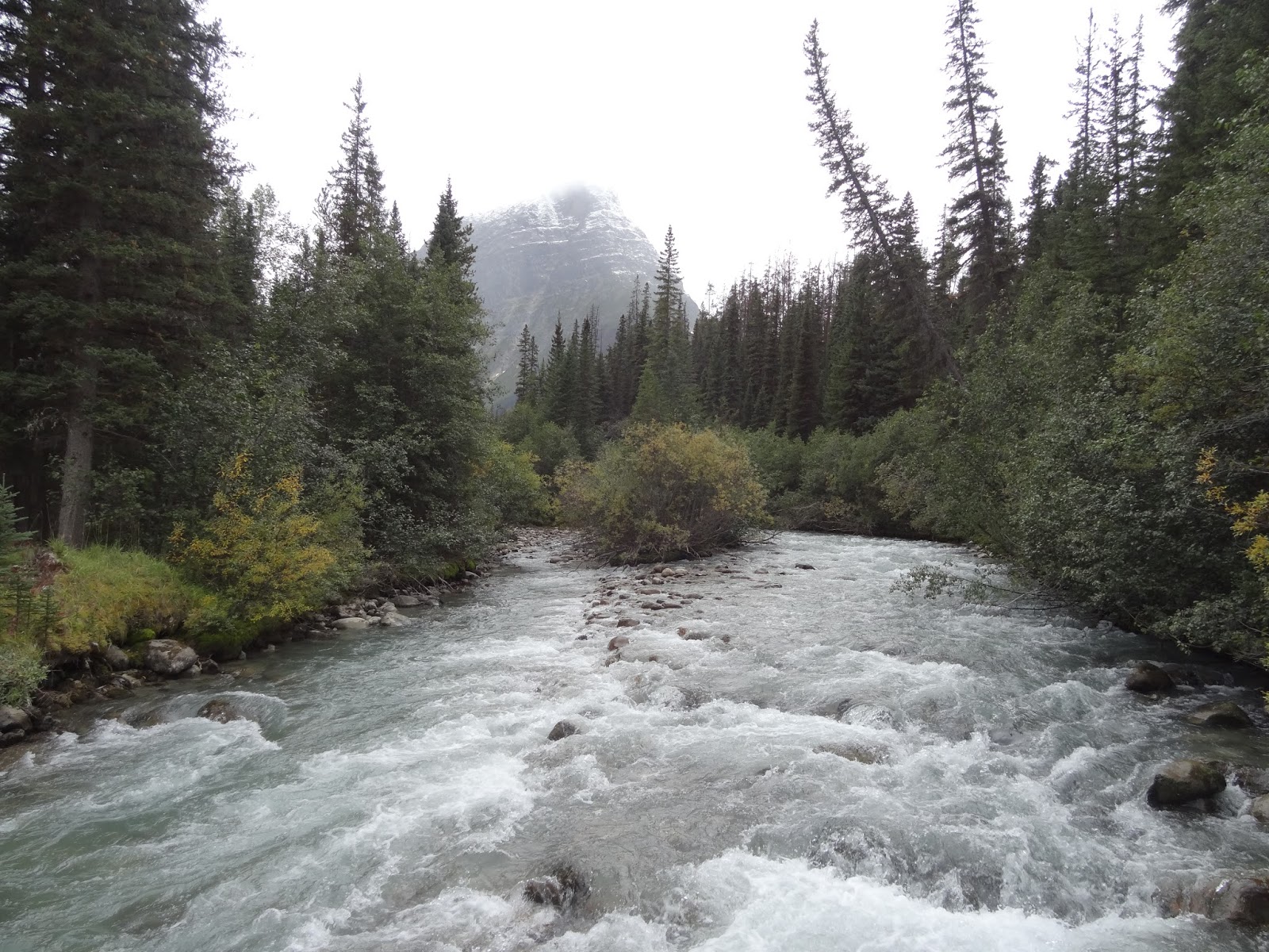
fter 2.6km of trail you get to Tie Camp and come out of the forest for a short section and get to see the river. This was our view. Simon Creek comes out of that valley down there. We still have a long way to go.
Back into the forest you get more creek crossings. This one had some trees cut down to help you across.
Then 4km later you get to Simon Creek which has a lovely bridge crossing it. The only lovely bridge on the trail. Well I suppose there is the one that spans the empty creek bed of the old Middle Whirlpool River path. On the other side of Simon Creek is another camp that is not on the Gem Trek map (why?).
Then there is 5km through forest with a lot of small and seemingly unnecessary elevation gains and losses. I really didn't like that section of trail. Could be because we did it at the end of the day on the way in and out. Or it could just be a terrible section of trail. The final 1km to Middle Forks Campground starts along the river then goes back into the forest where the bridge now not spanning the Middle Whirlpool River is. Then it comes up to the Warden Cabin. After the Cabin you come to the new course of the Middle Whirlpool River. It consists of a short deeper section and a larger washout shallow section.
This is the short deeper section. We crossed over the two logs on the left. When we came back Parks had cut down the smaller one. They deemed it unsafe as it didn't span the whole river. Indeed you couldn't walk on it.
Instead I came up with this method to get across. It was very easy and felt quite safe. We just didn't put our full weight on the lower log.
This is the large washout section. It is quite long. After skirting the river flowing over the trail you get to the main part of the river. A log spans the majority of this distance and we used it to cross.
Here is the log. It goes on for about three times this distance. Then we just jumped from bit of vegetation to the next, until we were back on the trail. Soon we were at Middleforks Campground. Quite unfortunately there was not really anywhere to set the tent down that wasn't covered in horse manure. I scrapped a bunch away and settled on the nicest spot and we got to cooking food. We had done 21km in total this first day.
(Day 2 - September 9 - Middleforks Campground To Scott Campground)
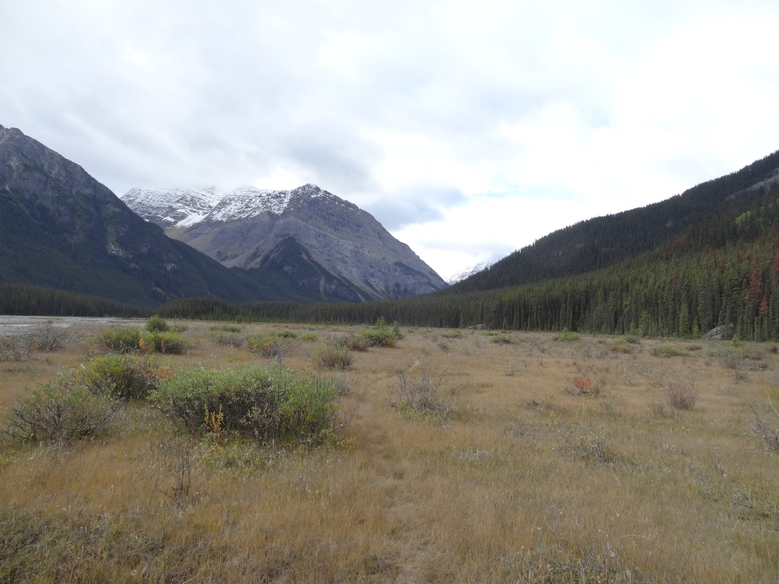
This day we moved camp up valley to Scott Campground. We were supposed to go on a side trip to see the Scott Glacier and its moraine lake up close, but we could not due to the bridge over the canyon being out. This was a real disappointment to me as it is one of the two highlights of the trip. The other being the pass of course. Seeing the glacier from the trail is very scenic as well, but just not the same. Scott Glacier Flats is the longest section of trail out in the open. Nearly all the 5km is out on the flats, so it was good walking.
This day starts by going ~500 meters along wet marsh/grass area in the open, before heading into the trees for ~4.5km.
Here is the grassy area before you head off into those trees.
In the trees you get two views of the river like this for short sections. Otherwise not much.
When we were going in there was a lot of deadfall on this section. Here is one of those lovely logs you have to ponder under or over about. Thankfully on the way out we saw fresh horse manure, and found that all the logs from the start of Scott Glacier Flats onwards were cut down. We later saw the Wardens who had done this great work. Its been a long time since I saw a Warden in the backcountry!
At the final section of trees you get one view down to what is about to come.
Then you turn a corner and your there. Scott Glacier Flats. This section is 5km long. You descend down and walk on the flats below here for ~500 meters. Then there is a hiker trail to avoid river channels that side-hills annoyingly for some time, then goes fully into the trees for a short section, before letting you out on the flats again for good until their end.
Here we come out to the flats. The trail is very indistinct at the beginning. We stayed far too close to the trees on the right here. Instead the actual trail goes across to meet the main Whirlpool River channel, and then follows along it till the flats end at Scott Campground. It gets more distinct as you go along, until it is fully formed again at the end. We found the campground alright anyway as it is very obvious.
As you walk along the flats you get better and better views of Scott Glacier coming off of the Hooker Icefield. Although it was a cloudy day we could see the Glacier itself well enough.
The sun even shone on it briefly.
Ice!
Once at camp we set everything up, then set off for what was to be our afternoon day hike to the edge of the Glacier and back. This starts off on a side trail along the Whirlpool river that leads shortly to a canyon.
The canyon here is where the bridge used to be. It clearly no longer was here. I worried it was the wrong place and bushwhacked further upstream but to no avail. Not only could we not find the bridge, we couldn't find a place to ford the river either.
The river by the canyon.
Further upstream it is still mostly the same. Very fast flowing and rocky.
The canyon again. This is where the bridge crossed. On the way out when we saw the Wardens, they told us that they had cut it down the previous year because it was very unstable and not safe at all to cross. I can imagine it would be very dangerous if unstable. If you fell here from the bridge it would certainly be fatal. They must have only picked this spot for a bridge before, because it was the shortest section of the river where it was sure not to change course. In terms of safety it isn't the best place for a bridge though.

Back at the campground I stared at the river and the glacier a long time as I filtered water. Although it is wider here, it is still very deep in the middle of the river. It must have been thigh deep or deeper for at least 5 steps or more. It was also following very fast. The current looked very strong and I am sure it was deceptive about just how strong it was even then. We did not attempt it. It could have been a bit better further down-steam somewhere in the gravel flats, but I did not investigate that. I really hope Parks puts up a new bridge somewhere here in the future so that people can enjoy this side trip again. It would be a shame if they never did because it is dangerous to head over there now. I think fewer people will head out on this trail if they don't. Although I wouldn't go back here, I still think its a worthwhile trip for backpackers who like the out-of-the-way wilderness treks.
On this day we only did 10km on the trail, and about 1km going up along the river looking for the bridge and back.
(Day 3 & Day 4)
(Day 5 & Day 6)


No comments:
Post a Comment